
Navimap
Navimap marine chart IT207-IT208
Sku code
70.101.06
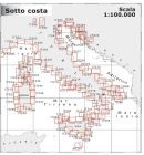
Navimap Coastal Charts 1:100.000 from Navimap Map Side 1 IT207 Area Side 1 From Punta Ala to Cala Galera with Giglio Isle and Giannutri Isle Map Side 2 IT208 Area Side 2 From Porto Ercole to Capo Linaro with Giannutri Isle Scale ...
More info
€32.16
€26.15
Out of stock
* Next shipping:
Your order will be shipped !
Accepted payments: *
Paypal
Credit Card
Bank money transfer
Braintree
Estimated delivery: *
Fast air delivery with DHL or UPS, 1 to 7 days worldwide !New york, Berlin 1 day, Hongkong, Dubai, Tokyo 2 days, Sidney, Cape Town, Rio de Janeiro 3 days

NAVIMAP Coastal Charts 1:100.000
47.7x69.7-cm size. The charts are made up of Side 1 & Side 2| Map Side 1: | IT207 |
| Area Side 1: | From Punta Ala to Cala Galera with Giglio Isle and Giannutri Isle |
| Map Side 2: | IT208 |
| Area Side 2: | From Porto Ercole to Capo Linaro with Giannutri Isle |
| Scale: | 100.000 |
We found other products you might like!
-
 Navimap marine chart IT213-A04s€32.16 €26.15
 -
Navimap marine chart CR202-CR203€32.16 €26.15
-
Navimap marine chart IT255-IT256€32.16 €26.15
-
Navimap marine chart IT216-IT217€32.16 €26.15
-
Navimap marine chart CR206-CR207€32.16 €26.15
-
Navimap marine chart IT261-IT262€32.16 €26.15
-
Navimap marine chart IT220-IT221€32.16 €26.15
-
Navimap marine chart IT236-IT238€32.16 €26.15
-
Navimap marine chart IT265-IT266€32.16 €26.15
-
Navimap marine chart IT224-IT225€32.16 €26.15
-
Navimap marine chart IT257-IT258€32.16 €26.15
-
Navimap marine chart IT269-IT270€32.16 €26.15
-
Navimap marine chart IT229-IT230€32.16 €26.15
-
Navimap marine chart FR207-FR208€32.16 €26.15
-
Navimap marine chart IT273-IT274€32.16 €26.15
-
Navimap marine chart IT234-IT235€32.16 €26.15
-
Navimap marine chart IT201-IT202€32.16 €26.15
-
Navimap marine chart IT277-IT278€32.16 €26.15
-
Navimap marine chart IT245-IT246€32.16 €26.15
-
Navimap marine chart IT205-IT206€32.16 €26.15
-
Navimap marine chart IT281-IT282€32.16 €26.15
-
Navimap marine chart IT249-IT250€32.16 €26.15
-
Navimap marine chart IT211-IT212€32.16 €26.15
-
Navimap marine chart YU201-CR201€32.16 €26.15
-
Navimap marine chart IT253-IT254€32.16 €26.15
-
Navimap marine chart IT214-IT215€32.16 €26.15
-
Navimap marine chart CR204-CR205€32.16 €26.15
-
Navimap marine chart IT259-IT260€32.16 €26.15
-
Navimap marine chart IT218-IT219€32.16 €26.15
-
Navimap marine chart CR208-CR209€32.16 €26.15
-
Navimap marine chart IT263-IT264€32.16 €26.15
-
Navimap marine chart IT222-IT223€32.16 €26.15
-
Navimap marine chart IT241-IT242€32.16 €26.15
-
Navimap marine chart IT267-IT268€32.16 €26.15
-
Navimap marine chart IT226-IT227€32.16 €26.15
-
Navimap marine chart IT271-IT272€32.16 €26.15
-
Navimap marine chart IT231-IT232€32.16 €26.15
-
Navimap marine chart FR209-FR210€32.16 €26.15
-
Navimap marine chart IT275-IT276€32.16 €26.15
-
Navimap marine chart IT243-IT244€32.16 €26.15
-
Navimap marine chart IT203-IT204€32.16 €26.15
-
Navimap marine chart IT279-IT280€32.16 €26.15
-
Navimap marine chart IT247-IT248€32.16 €26.15
-
Navimap marine chart IT209-IT210€32.16 €26.15
-
Navimap marine chart IT283-IT284€32.16 €26.15
-
Navimap marine chart IT251-IT252€32.16 €26.15
Write Your Own Review