
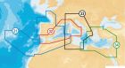
Navionics XL9-43XG nautical chart Mediterranean Black Sea Canaries and Azores
If you add more products to your cart, the shipping cost will drop to free shipping.
Shipping costs are calculated at checkout, based on the destination area, weight/volume and the total value of the cart.
We ship all orders from our warehouse in Italy with DHL express couriers.
Below you can see the basic costs by continent, to know the exact price, add the items to the cart and enter the shipping country in the checkout page.
Europe, UE and extra UE by track or by air (Delivery 1-5 business day):
| (vat excluded) | Shipping price starts from (*) | Delivery Time (**) |
|
Austria, Belgium, France, Germany, Italy, Luxembourg, Holland |
9,80 € | 1 day |
|
Croatia, Denmark, Finland, Greece, Ireland, Portugal, United Kingdom, Spain, Sweden |
12,20 € | 1 day |
|
Andorra, Bulgaria, Estonia, Latvia, Liechtenstein, Lithuania, Norway, Poland, Czech Republic, Romania, Slovakia, Slovenia, Switzerland, Ungeria |
13,80 € | 1-3 days |
International by air (Delivery 1-7 business day):
| Shipping price starts from (*) | Delivery Time (**) | |
|
North America |
17,50 USD | 1 - 2 days |
|
Africa, Asia, Oceania, South America |
29,70 USD | 2 - 7 days |
(*) The prices shown are the basic minimum, for a total weight / volume cart of less than 0.5 kg.
(**) Refers to the DHL shipping method. Remote areas may take additional days.
New york, Berlin 1 day, Hongkong, Dubai, Tokyo 2 days, Sidney, Cape Town, Rio de Janeiro 3 days

NAVIONICS maps
Navionics Platinum:multi-dimensional Navionics mapping with 3D visualisation - satellite and aerial pictures - panoramic harbour pictures - harbour services and points of interest - dynamic tide icons
Navionics Gold:
exceptional detail - bathymetric lines - harbour plans - currents and tides - services - excellent coverage.
Navionics +:
exceptional detail - bathymetric lines - SonarChart™ - Auto-routing - Plotter Sync - harbour plans - currents and tides - services - excellent coverage. Chose between 29.080.08 (Mediterranean Sea areas Black Sea Canary Islands and Azores) and 29.080.11 (empty). This latter can be downloaded by the final user with one of the XL9 Navionicswidthareas from navionics.com.
NavionicswidthSmall:
exceptional detail - bathymetric lines - SonarChart™ - Auto-routing - Plotter Sync - harbour plans - currents and tides - services. SD/Micro Sd card sold empty: the user can download the desired Italian or European areas among those indicated here below from navionics.com. It is also possible to download the Mediterranean Sea maps or the map of similar areas paying the difference on navionics.com.
| Mapping model: | Navionicswidth43XG |
| Electronic support: | SD / Micro SD |
| Size: | XL9 |
-
 Navionics XL9-GOLD-CF nautical chart€321.62 €261.48
 -
Navionicswidthempty Sd /Micro Sd XL9 nautical chart€271.20 €220.49
-
Navionics Platinum Compact flash XL3nautical chart€392.19 €318.85
-
NavionicswidthSmall nautical chart€171.29 €139.26
-
Navionics Platinum Compact flash Xl nautical chart€261.13 €212.30
-
Navionics Platinum SD/Micro Sd XL3 nautical chart€392.19 €318.85